Understanding Williamson County impervious cover limits is important before building a home, driveway, commercial property, or other improvements on land affected by Edwards Aquifer regulations. Impervious cover can include surfaces that prevent rainfall from naturally soaking into the ground, which can affect drainage, groundwater recharge, and water-quality protection. The applicable requirements depend on the property’s location, development type, regulatory jurisdiction, and whether the property falls within an Edwards Aquifer protection area.
For property owners, developers, builders, and designers, checking these requirements early can prevent costly changes later. A properly prepared site plan can help identify proposed buildings, driveways, parking, patios, drainage features, easements, and other improvements before construction documents are finalized.
What Is Impervious Cover?
Impervious cover generally refers to constructed surfaces that prevent or significantly reduce rainfall from infiltrating the soil. Common examples can include building foundations, concrete areas, paved driveways, parking areas, sidewalks, and other constructed surfaces, depending on the applicable regulatory definition.
The important point is that impervious cover is not limited to the footprint of the house. A property may have a relatively small building but still have substantial impervious coverage because of:
- Driveways
- Parking areas
- Patios
- Walkways
- Garages
- Access roads
- Additional structures
- Other qualifying constructed surfaces
When planning a property, you should evaluate the entire proposed development rather than looking only at the main building.
Why Impervious Cover Matters in Williamson County
Parts of Williamson County are located within areas associated with the Edwards Aquifer system. The aquifer is an important groundwater resource, and development in regulated areas can be subject to requirements intended to protect water quality and manage the effects of development.
Impervious surfaces can change how rainfall moves across a property. Instead of infiltrating naturally, water may flow across roofs, pavement, concrete, and other surfaces before entering drainage systems or nearby areas.
This can affect:
- Stormwater runoff
- Drainage patterns
- Soil infiltration
- Erosion potential
- Groundwater recharge
- Water quality
For this reason, impervious cover can become an important consideration during property development and site planning.
What Is the Edwards Aquifer?
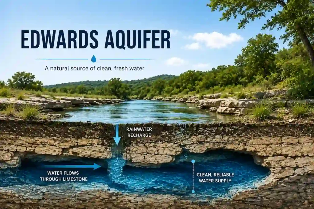
The Edwards Aquifer is a major groundwater system in Central Texas. It supplies water to communities, businesses, agriculture, and natural ecosystems.
Because portions of the aquifer are vulnerable to contamination from surface activities, development controls apply in designated areas. The exact requirements depend on the property’s location and the regulatory program that applies to it.
A property owner should therefore determine whether the property falls within a regulated Edwards Aquifer area before finalizing a development plan.
Edwards Aquifer Recharge and Contributing Areas
The Edwards Aquifer regulatory framework includes different geographic areas with different characteristics and requirements. The recharge zone is particularly important because water can enter the aquifer through exposed or highly permeable geological formations.
The contributing zone is an area where water can flow toward the recharge zone. Development requirements can differ depending on the property’s location within these mapped areas.
You should never assume that two properties in Williamson County have identical impervious cover requirements simply because they are located in the same county. The property’s mapped location, local jurisdiction, development type, and applicable regulations all need to be considered.
How Are Impervious Cover Limits Determined?
There is no single percentage that automatically applies to every property in Williamson County.
The applicable limit can depend on factors such as:
- Property location
- Edwards Aquifer regulatory area
- Development type
- Site characteristics
- Applicable state requirements
- Local development regulations
- Existing conditions
- Project scope
- Required water-quality controls
This is why online examples or a percentage from another property should not be treated as a final answer for your project.
Before designing the home or other improvements, determine which requirements apply to the actual property.
How Is Impervious Cover Calculated?
A basic impervious cover calculation can be expressed as:
Impervious Cover Percentage = Total Qualifying Impervious Area ÷ Applicable Site Area × 100
For example, assume a property has 15,000 square feet of applicable site area and the proposed improvements include 5,000 square feet of surfaces that qualify as impervious under the applicable rules. The simplified calculation would be:
5,000 ÷ 15,000 × 100 = 33.3%
This example is for illustration only. The actual calculation may depend on the regulatory definition, property boundaries, exclusions, existing conditions, and applicable Edwards Aquifer or local requirements.
For projects where the calculation is important to feasibility, using a lot coverage calculator can provide an initial planning estimate, but the applicable regulatory definition should still be confirmed before relying on the result for permitting.
What Surfaces Can Affect Impervious Cover?

The exact treatment of a surface depends on the applicable rules, but a development plan may need to evaluate:
- House footprint
- Garage
- Driveway
- Sidewalks
- Patios
- Parking areas
- Access roads
- Detached structures
- Other paved or constructed areas
Landscaped areas and natural ground generally function differently from constructed impervious surfaces. However, you should not assume that every surface is automatically excluded or included without checking the applicable definition.
This distinction matters when a project is close to an impervious cover threshold.
Why Your Site Plan Matters
A site plan provides a visual representation of how the proposed improvements will fit on the property. It can show the building footprint, driveway, parking, walkways, existing structures, property boundaries, easements, setbacks, and other relevant features.
A properly prepared site plan can also help you identify how proposed improvements affect the total developed area before construction begins.
For example, moving a garage, reducing driveway width, changing a patio layout, or adjusting building placement may affect the amount and distribution of impervious surface on a property.
Site planning should therefore happen before final construction decisions are made.
Impervious Cover and Residential Development
Homeowners often focus on the size of the house when planning a property. However, the surrounding improvements can also affect the site’s overall impervious coverage.
A residential project may include:
- Main residence
- Garage
- Driveway
- Pool
- Patio
- Walkways
- Outdoor structures
- Parking areas
A residential site plan can organize these components and show their relationship to the property boundaries and other site constraints.
If the property is close to an applicable impervious cover limit, design decisions should be made with the entire site in mind rather than adding paved areas later.
Impervious Cover and Commercial Development
Commercial properties can involve substantially more impervious surface because they may require buildings, parking lots, drive aisles, sidewalks, loading areas, and other site improvements.
Commercial development may therefore require more detailed site analysis and coordination.
A commercial site plan can help organize the proposed building, parking, access, circulation, and other site components before the project proceeds to later stages.
The applicable water-quality, drainage, and development requirements should be reviewed based on the specific property and proposed use.
What Happens If a Project Exceeds the Applicable Limit?
If proposed development does not satisfy an applicable impervious cover requirement, the project may need to be redesigned or additional measures may be required under the applicable regulatory program.
Potential design changes can include:
- Reducing paved areas
- Modifying the building footprint
- Changing driveway dimensions
- Revising parking layouts
- Adjusting site circulation
- Using alternative site design approaches
- Incorporating required water-quality controls where applicable
The appropriate solution depends on the property and regulations. It is better to identify the issue during planning than after construction documents have been completed.
How to Check Williamson County Impervious Cover Requirements
Start with the property rather than a general countywide percentage. The applicable requirements can depend on the property’s exact location, jurisdiction, regulatory area, and proposed development.
1. Confirm the Property Location
Determine the exact jurisdiction and location of the property before reviewing impervious cover requirements. This helps identify which state, county, municipal, and environmental requirements apply to the project.
2. Review the Property Survey
Review a current property survey to identify the lot boundaries, existing structures, easements, and other important site conditions. This information provides the starting point for evaluating existing and proposed impervious areas.
3. Check Edwards Aquifer Mapping
Determine whether the property is within an applicable Edwards Aquifer regulatory area. If it is, additional development and impervious cover requirements may apply to the project.
4. Identify Development Requirements
Review the state and local development requirements that apply to the property and proposed project. Consider the jurisdiction, environmental regulations, and other site-specific requirements before calculating the allowable impervious area.
5. Calculate Proposed Impervious Area
Measure the building footprint and other proposed surfaces that may qualify as impervious cover. This can include driveways, patios, sidewalks, parking areas, pool decks, and other constructed or paved surfaces.
6. Prepare the Site Plan
Prepare an accurate site plan showing the property boundaries, existing structures, proposed improvements, impervious areas, easements, and other relevant site features. This makes it easier to identify potential conflicts before submitting the project for review.
7. Complete the Required Review
If the project requires formal documentation or review, submit the appropriate materials to the applicable authority and address any comments or corrections. A professional site plan review can help identify site-related issues before the project reaches construction.
Documents You May Need
Depending on the project, useful information can include:
- Property survey
- Recorded plat
- Site plan
- Existing building information
- Proposed floor plan
- Driveway dimensions
- Parking layout
- Easement information
- Drainage information
- Property restrictions
- Applicable regulatory maps
Having these documents available early makes it easier to evaluate the property accurately.
Common Mistakes Property Owners Make
Using a Countywide Percentage
A percentage that applies to another property may not apply to yours.
Counting Only the House
Driveways, parking, patios, and other improvements may also need to be considered.
Designing Before Checking the Property
Creating a detailed design before reviewing the site can result in unnecessary revisions.
Ignoring Easements
An easement may restrict where buildings, driveways, utilities, or other improvements can be placed.
Treating Lot Coverage and Impervious Cover as Identical
These terms can have different definitions depending on the applicable program. Use the correct regulatory definition when calculating compliance.
Waiting Until Permit Submission
Finding an impervious cover problem during review can require changes to an otherwise completed design.
How to Plan a Property With Impervious Cover Limits in Mind
Start by identifying the property’s constraints before deciding where every improvement will go. Place the primary building first, then evaluate the driveway, garage, parking, patios, walkways, and other improvements. Keep accurate measurements for each proposed surface. Compare the proposed layout against the applicable requirements before finalizing the design. This approach can also help you make practical decisions about where to reduce unnecessary paved areas without compromising the functionality of the property.
Final Thoughts
Williamson County impervious cover limits can be an important consideration for property owners planning residential or commercial development in areas affected by Edwards Aquifer requirements. The applicable standard is not necessarily the same for every property, so relying on a general percentage can lead to inaccurate conclusions.
Start with the actual property. Review the survey, identify the applicable regulatory area, evaluate proposed impervious surfaces, and prepare a site plan that reflects the complete development. A properly coordinated plan can help identify problems with building placement, driveways, parking, easements, drainage, and impervious surface area before construction begins. Because regulatory requirements can change and may vary by property and jurisdiction, verify the current requirements with the applicable authorities before relying on a calculation for permitting or construction.
Frequently Asked Questions
What are Williamson County impervious cover limits?
They are requirements that can restrict the amount of qualifying impervious surface permitted on certain properties. The applicable limit depends on the property’s location, regulatory area, development type, and other requirements.
What is impervious cover?
Impervious cover generally refers to constructed surfaces that prevent or reduce natural rainfall infiltration, such as buildings, pavement, driveways, and other qualifying surfaces.
Does every Williamson County property have the same limit?
No. Requirements can vary based on location, regulatory area, development type, local rules, and property-specific conditions.
Does the Edwards Aquifer affect Williamson County development?
Yes, properties within applicable Edwards Aquifer protection areas can be subject to development and water-quality requirements.
Do driveways count toward impervious cover?
A driveway may be considered impervious cover under applicable regulations. Confirm the treatment of the specific surface before calculating compliance.
How do I calculate impervious cover?
A basic calculation divides the total qualifying impervious area by the applicable site area and multiplies the result by 100. The regulatory definition should be confirmed for the specific property.
Do I need a site plan?
A site plan is useful for showing the building footprint, driveway, parking, easements, property boundaries, and other improvements. Local authorities may also require site documentation for certain projects.
Can I reduce impervious cover through site design?
Potentially. Reducing paved areas, modifying building placement, and adjusting other site improvements may reduce the total impervious area. The appropriate approach depends on the property and applicable requirements.
What should I check before building?
Review the property survey, jurisdiction, Edwards Aquifer mapping, easements, development requirements, proposed impervious surfaces, and any applicable private restrictions before finalizing the design.
Can a site plan help with impervious cover planning?
Yes. A site plan can show the complete arrangement of proposed improvements and help identify potential impervious cover and site-planning issues before construction or permitting.
Is impervious cover the same as lot coverage?
Not necessarily. The terms can have different definitions depending on the applicable regulatory program. Use the definition required for the specific project when determining compliance.